
Hurricane Sandy Called 'One in 30 Year Storm' http://abcn.ws/Y5jqS5

 ABC News


10:04 PM - 26 Oct 12 · Details
Hurricane Sandy Barrels Up East Coast; Officials Warn Residents to Prepare
Oct 26, 2012
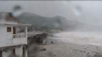
Cocoa Beach is one of the widest beaches in Florida -- but not tonight.
Because of Hurricane Sandy, centered far to the East near the Bahamas, the beach is almost 100 yards narrower as the ocean surges in, giving an indication of how strong the storm is. Cocoa Beach was experiencing waves as high as 10 feet right on shore and was expecting wind gusts up to 60 mph tonight.
But Florida may get off relatively easy on this one. This storm appears poised to move northward parallel to the East Coast before turning to make landfall in the Northeast. Current forecasts suggest a possible landfall Tuesday in the vicinity of New Jersey, but with a broad swath of harsh conditions also hitting surrounding states.
Meteorologists are predicting that Sandy, now a category 1 storm, is turning into an "extra-tropical cyclone" that will hit a broad region with 50 mph winds and rain and storm surges as it barrels up the East Coast toward New York, in what some are calling the "storm of the century."
Forecasters fear up to 10 inches of rain turning into two feet of snow in higher altitudes could hit the East Coast next week, and are warning that the track could still change as much as 200 miles.

Joe Raedle/Getty Images
Stephanie Bilyeu walks along the ocean as... View Full Size

Hurricane Sandy on Path to East Coast Watch Video
Hurricane Sandy: When Storms Collide Watch Video

Hurricane Sandy Could Be 'Perfect Storm' on East Coast Watch Video
"This storm has -- it certainly has the potential to stand on its own. We are dealing with categories we don't normally see here," Dr. Louis Uccellini, director of NOAA's National Centers for Environmental Prediction, said.
Uccellini said that it's still too soon to tell who's going to get hit -- and how hard -- as the storm moves back toward the East Coast, and that this storm has "some similarities" to the so-called "perfect storm" of 1991 that hit with massive waves and coastal flooding, killing 13.
"There will be significant surge with this as the storm moves from the Southeast to the Northwest towards the coastline, and that's going to become a very important part of the forecast for us as we near this event at the beginning part of the week," he said. HURRICANE SANDY: LIVE STORM TRACKER By next week Sandy is expected to turn into a winter storm hybrid -- dubbed a "Frankenstorm" by National Oceanic and Atmospheric Administration forecaster Jim Cisco -- and could ravage the coast with tropical storm winds.
"This is not being overhyped. I would use the terms 'devastating' and 'historic,'" Accuweather's Bernie Rayno said. "A one-in-30 year storm, or even in the fact the way this storm is going to be tracking east toward the coastline in New Jersey, it could be a once-in-a-lifetime storm."
Along the Jersey Shore, emergency management officials are counting on mounds of sand as their first line of defense against an anticipated storm surge. Locals are anticipating mandatory evacuations, and voluntary evacuations are already underway in Cape May County, on New Jersey's southern tip.
Up and down the East Coast tonight, utility workers are out in full force preparing for potentially extensive power outages, with states calling in hundreds of extra workers.
As for residents, they're getting ready in case they have to spend a few days in the dark, stocking up on essentials such as generators, which many stores sold out of this morning. The shortages meant that generators that would normally average about $500 were being sold online for as much as $1,400.